This tramp is a circuit with some excellent up and down, and great huts to relax and have a dram at. And of course to progress the bible free Tararua's agenda that is normal secular activity for Forest and National Parks.
Was to meet up with Jesse at Totara Flats hut on Friday night, however when I got there he wasn't there. I left a few hours after him so assumed he must have not come.
Friday 08/11/2013 and Saturday 09/11/2013
Left Wellington as soon as I could after sorting some issues and drove to Holdsworth car park. Headed off just on nine pm. Got to Totara Flats in a nice time, even though the track has had all the orange triangles removed. Is this more DOC spending cutbacks? Recycling the plastic? Stopped at Totara Flats for half an hour and had a hot drink and snack. Left just on midnight to head to Neill Forks all seemed to be going well.
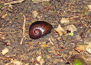
So as I headed up Cone Ridge ran into that dense misty stuff that makes travel a bit tricky. No probs I know the track. Lots to see, snails, millipedes, and spiders.
However some time later I realised I should have hit the track leading down to Neill Forks. and thought another fifteen minutes. Walked past a familiar rock, so familiar that an hour back I'd realised I always have a memory of it. Compass out and I was heading North, the wrong way. Earlier I had lost the track for a bit then got back on it, but in doing so had done a turn about, ended up heading back out. Shit happens, a good laugh and probably lost an hour.
Got to Neill Forks after four am, so time for a can of beer, snack, and sleep.
Saturday 09/11/2013
Late arrival meant did not wake up till lunch time. Left Neill Forks after one pm and across the swing headed up to Maungahuka.
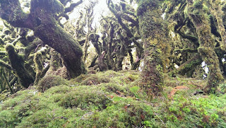
An excellent day, almost no wind and nice temperature, great views, forest of twisted trees and a session barking at a dear. It bark, I bark, it bark, I bark and so on until it left; never saw it.
Once out on the open tops there was cloud coming and going and views for mile, looking South, at the cloud chasing me.
And looking West, the most distant is Kapiti Island, all fading grey.
Cloud finally caught and engulfed me just before I got to Maungahuka, swirled up and clagged in minutes.
Stopped at Maungahuka for snack and drink as misty Tararua clag stuff continued to roll in.
Then on to Aokaparangi for the night, was intending to get to Mid Waiohine, but the track down thru the bush isn't something I want to try in the dark. On Simpson had some darkening views.
So Aokap it is and almost there.
Aokap is a great place for a few drams, had Smokehead, Glendronach 12 yo and a Kilchoman Machir Bay 2012.
Sunday 10/11/2013
Out of bed at nine am and off after breakfast of coffee coffee and some food.
And then up to the top with some views.
and down thru the forest to Mid Wiaohine.
Stopped for a long lunch, swim and sunbath at the hut. The sort of day that makes me think it aint the Tararuas, so sunny and nice, more like Nelson. And its a wee bit icky this bruise of mine, after leaving Mid Wiaohine heading up the hill I fell off the track and bounced off a tree stump. Bit of an impact as the photo a few days later shows :-).
Off up Isabelle and such blue sky as I came out of the bush.
Across to Holdsworth with the wind speed picking up. Got to Powell and its a bit of a gale. Stopped for a hot drink and texted Jessie and got the knowledge on the lostness and darkness with no orange triangles.
Left the hut heading down to Holdsworth car park and home.
Map of Circuit
Elevation Profile
Density
Two more huts in the Tararua's got the bible free tag. Aokarparangi and Mid Waiohine.
Trip Times
Friday 08/11/2013
2100 Left Holdsworth car park
2202 Totara Flats, Pig Flat junction
2234 Totara creek
2321 At new bridge
2337 Totara Flats hut
2359 Off to Neill Forks hut
Saturday 09/11/2013
0314 At junction on Cone ridge, been lost
0418 Neill Forks hut
1321 Left Neill Forks hut
1557 Out of bush onto open tops
1644 On Maungahuka
1653 Maungahuka hut
1728 Left Maungahuka hut
1916 Turn off to Aokaparangi Hut
1928 Aokaparangi Hut
Sunday 10/11/2013
0958 Left Aokaparangi Biv
1030 On top of Aokaparangi
1159 Crossed bridge over Waiohine
1215 At Mid Waiohine hut
1406 Left Mid Waiohine hut
1739 Isabelle
1809 Powell hut
1833 Mountain House shelter
1857 Totara Flats Pig Flat junction
1956 Holdsworth car park
Almost done. Let your mind be free...


