Ruahine Forest Park Oroua Catchment

The car park at the end of Petersons road provides good access to the Oroua River and Ngamoko Range, which enables a weekend tramp that can bag at least six huts; as does the Limestone Road car park.
Table Flat Road ends
Friday 25/11/2016
Was raining as I drove to the road end, by the time I was ready to go, the rain had stopped.
Bridge the gap bridge
Nice walking night to Iron Gate hut, did stop at Alice Nash Memorial Heritage Lodge to check the hut out. There are some good info signs along the way that present the early logging history.

Saturday 26/11/2016
Nice sleep in and relaxing breakfast with a clean up before heading up to the Ngamoko Range.
Iron Gate Hut
Interesting walk up thru a montane conifer type forest.
Forest on way to Ngamoko tops
When I first got out onto the range it was sunny with views, before I got to 1505 to head down to Top Gorge hut it was raining, windy, and visibility had dropped. Used compass to ensure I was heading down the right ridge, down lower an obvious trail exists.
Ngamoko Range as got out of the bush
Heavy rain by the time I arrived at Top Gorge Hut. The track down from the tops dosn't seem to get much use, quite a few visits in the hut book where river trips. The hut is built on a concrete pad, has not been lined, and has an open fire place. Stopped here for lunch and once the rain calmed down headed up the ridge for a bush bash.
Top Gorge Hut
Top Gorge Hut
Top Gorge Hut
The last few hundred meters thru the Leather Wood was very scratchy, sliding on my tummy thru the shrubs with the rain was not really that bad, it was the pushing thru that was the worst. Thinking of coming back and cutting a real track here. Onto the DOC maintained track, easy going all the way to  Makaretu Hut, and got there just before the clouds opened again. Comfy little hut that was easy to warm up with once the fire was going.
Makaretu Hut
Sunday 27/11/2016
Left Makaretu Hut and took the track that is more direct up heading East. A ridge of large trees and mixed.
Forest on way up
Passed a NZ Forest Service enclosure on the way up.
NZFS enclosure
Did have one or two views on the way.
Forest

Best views of the day
At Leon  Kinvig Hut for lunch, rather wet with consistent rain and chilly wind gusts.
Leon Kinvig Hut
Nice grind up to Toka, once out of the shelter the wind blasts made me divert from my intended route,  of along the range to Tunapo and bagging Toka Bivouac on the way, to straight down Knights Track and ending up at Limestone Road end with an hours walk back to my car. The weather was very "hypothermic" that afternoon up on the range.
Toka 1519m
Map of Trip
Ngamoko Range from BL36
Trip Times
Friday 25/11/2016
1959 Left car at Oroua Catchment car park
2023 Alice Nash Memorial Hut
2029 Left Hut
2224 Iron Gate Hut
Saturday 26/11/2016
1102 Left Iron Gate Hut
1429 Top Gorge Hut
1530 Left Top Gorge Hut
1632 Joined the track 
1720 Spur down to Makaretu Hut
1757 Makaretu Hut
Sunday 27/11/2016
0923 Left Makaretu Hut
1049 Onto the Main Track
1104 Next Junction
1144 Leon Kinvig Hut
1253 Left Leon Kinvig Hut
1442 Top of Toka
1616 Limestone Road end
1724 Back at my car


Egmont National Park Hut Bagging

There are a few scattered huts left from other trips in Egmont National Park, this weekend I aimed to see if I could visit them all. Left late as had family things to do, and the road was not busy at all. Took State Highway 1 to Bulls and then onto State Highway 3, all the way to Inglewood, then up Egmont Road to the North Egmont visitors car park.

Huts Bagged
  • Maketawa Hut
  • Little Maketawa Hut
  • Manganui Lodge
  • Manganui Public Shelter  (not yet on Hutbagger site)
Saturday 19/11/2016
Left Wellington at about 1630 and headed for Inglewood, then up to North Egmont visitors Center to park up.
Approaching Mt Taranaki
Left the car a few minutes before ten p.m. and wanted to get to Maketawa hut before midnight, got there with an hour to spare. People where in the two sleeping rooms sleeping. In the main room a mattress had been left, so that is where I slept. Had a cup of tea and a dram before bed.

Sunday 20/11/2016
Out of bed early and a fine breakfast with some views from the Maketawa Hut veranda.
View East from Maketawa Hut
Packed up and off down the Maketawa Track and back up to the car at the visitors center, then drove down Egmont Road to Ngatoro car park to head into Little Maketawa Hut. The Ngatoro track is well marked and a few minutes after leaving the car park crosses the Waiongana Stream.
Waiongana Stream
Continuing South East for another 500 meters and when the track heads South West, continued South East. There is a sign for a track called "No Access".
No Access Track
Followed this track South East for 2.5 kilometers to a junction after crossing Little Maketawa Stream, took the track North East heading down river to the Little Maketawa Hut. A very nice spot with a rustic hut that is well maintained.
Little Maketawa Hut
There seems to be some issues with reality and DOC? Have been noticing that the DOC physics do not conform to the real world, like there hours are less than 60 minutes, more like 30 minutes.
Outdated nonsense
Had my lunch here and then it was back the same way to my car and another drive to bag another hut. So back down Egmont Road to Inglewood and South along State Highway 3 to Stratford with some views along the way.
View driving from Stratford
Up Pembroke Road to East Egmont car park and the start in a easy travel road to the flying fox, then its thru the tunnel.
Manganui Gorge Track tunnel
On along the track down into the gorge and up the other side and out to the two large buildings.
Manganui Public Shelter
Manganui Lodge
The Manganui Public Shelter would be a good place to crash on a Friday night as there is water, lights, and toilets. Back at the car before I drove off had no clouds covering Taranaki for a few minutes.
Mt Taranaki from South Egmont car patk
Map of the Trip
blue = wander lines
Trip Times
Saturday 19/11/2016
2158 Left car at North Egmont Visitor Center, headed up North Egmont Summit Track
2238 Summit track Maketawa track junction
2253 At Maketawa Hut
Sunday 20/11/2016
0713  Left Maketawa hut
0803 At the car park
0818 Heading to Little Maketawa Hut from the Ngatoro car park
1110 At the hut - what a walk!
1158 Left Little Maketawa Hut
1408 At Ngatoro car park, drove off to South Egmont car park
1526 Left car at South Egmont car park and headed for Manganui Lodge
1550 At Manganui Lodge
1620 Back to car, now a long drive home

Quake Day Attempt 2 on Orange Hut No, 3

Monday started with some shaking and early in the morning got a text from work stating "No work today". Had a nice sleep in and and wasted the afternoon before the thought of doing a quake day hut bag occurred. A quick bag pack, later it turned out it was a much too quick of a bag pack, and left Wellington at about three o'clock, heading straight to the car park, parked up. Headed off to get to Orange Hut No. 3, its a nice stroll through some trees and then onto farm land.
Track is flat farmland following a creek before a climb
Hadn't bothered to check weather, clouds seemed a bit ominous.
Dark clouds coming
Spotted a very interesting fungi on the walkway, just a little bit magical, not long after this the clouds rolled in and small rain fell, getting heavier.
Psilocybe mexicana
Kept on up and got to the top and crossed a fence into young pines, and about then the weather turned to hard heavy rain with a bit of a chill wind. Drenched rather quickly. Did think I could keep going and stay the night returning the next day. Thought about what I didn't put in my pack and said nah. So at quarter past five headed back down and drove home.

Tongariro National Park Hut Bagging

Headed away on Saturday afternoon for some hut bagging, was not in any sort of rush. Had a drive to do and then an easy walk into a hut for the night and an expectation of a few more huts on Sunday before the drive home.

Saturday 12/11/2016
Drove North on Highway 1 all the way to Waiouru then headed East on Highway 49 to Ohakune. Entered Tongariro National Park just on 6:00 pm. Drove up to the Waitonga Falls car park intending to head into Mangaehuehu Hut for the night with a quick detour on the way to visit Lupton and Blyth,  first I wanted to find Mangaiti Hut. Thought I would find a track entrance, however I went up and down the road and failed. Decided I would find it on Sunday time to head off and had a view of the mountain in the open before dropping down to the falls.
Mountain view
Down to the falls and then a wade thru a small river then up a ridge and out in the open just before Lupton Hut with a family staying there for the night.
Lupton Hut
From here it was less than ten minutes to Blyth Hut, with good cell coverage, so bagged the two huts so far.
Blyth Hut
Stopping for a drink and a snack turned out to be a good thing as it began to rain heavily, settled in for the night and got the fire going. Had two drams for the evening, a Springbank 15yo and a Glendronach 21yo, both in 50ml bottles.
Springbank 15yo and Glendronach 21yo miniatures
Sunday 13/11/2016
Once out of bed and fed, did some hut tidy (no hearth broom), and prepped some fire wood, then headed off into mild rain stopping at Lupton for a brief look at the hut.
Clean and tidy hut
Down to the junction and off to Mangaehuehu Hut for lunch, meeting a French man doing the Round the Mountain Track on the way. When I left it was raining and there was no visability, a nice fast walking day.
Down valley from Lupton Hut - no vis
Over a distance of a few kilometers I counted over one hundred 1080 pellets on the ground and did not see a single dead bird, dog, deer, or any pseudo scientist. Go the science! There is some good reading to be found at these following links:

Reports, reviews and regulation of 1080
1080:THE FACTS

If you want some entertainment have a read of these web sites:


1080 Frequently Asked Questions
1080Science

Had lunch at Mangaehuehu Hut, cleaned the hut for Seek Freedom, weather had started to clear and could see blue sky.
View towards Girdlestone Peak
Packed up and wandered outside hoping for it to fully clear, not so. Wandered off back the same way I'd come to go find the Mangaiti Hut, drying out as I went.
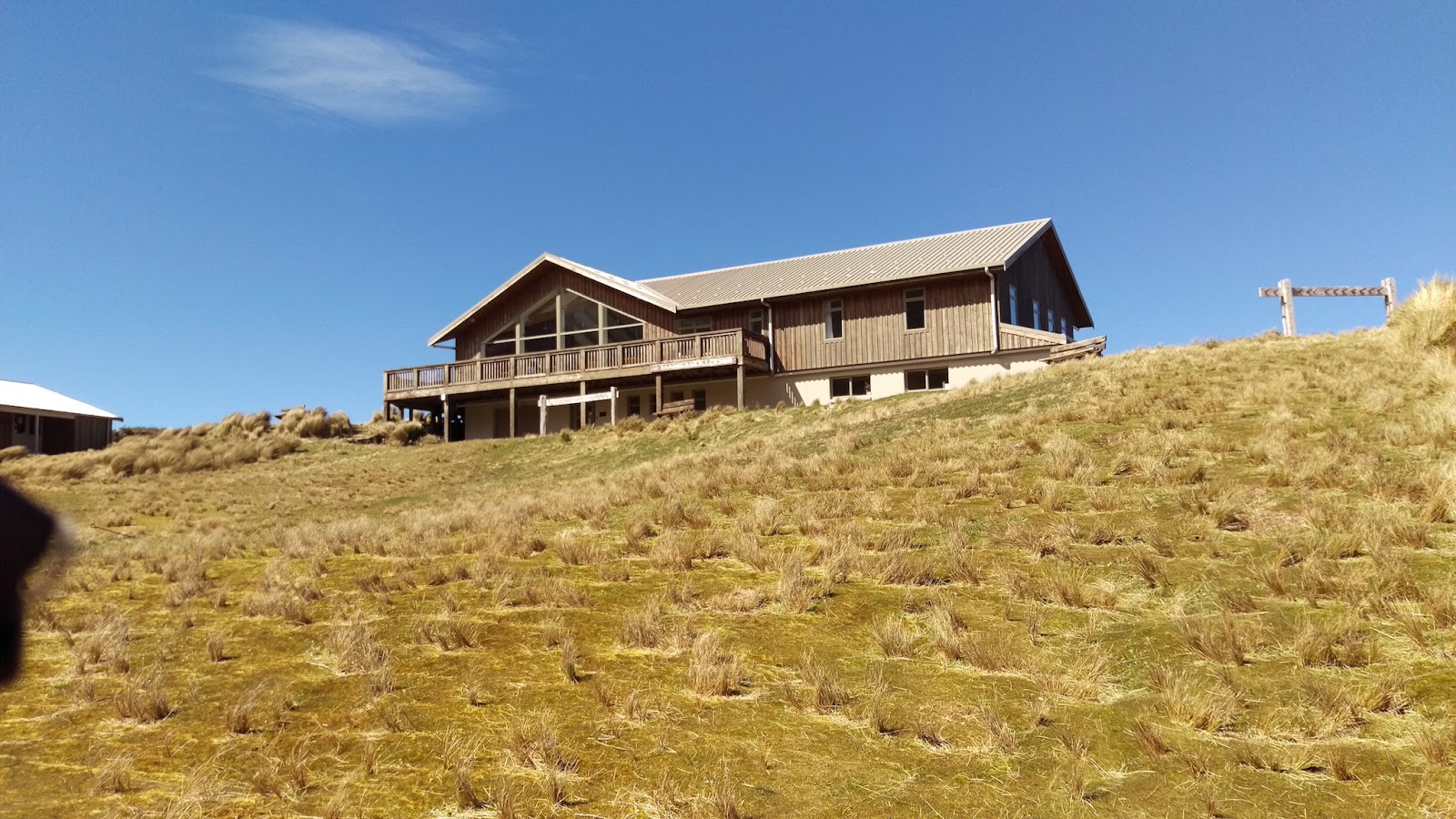
Mangaehuehu Hut
Not a long or strenuous walk to bag four huts, could be done easily as a day walk. Some nice forest and scenery here.
In the dark these snag you with tree dreams.
Back at the car and time to find Mangaiti Hut, and I did this by walking straight into the bush and headed West expecting to find a trail to it or the hut itself. Not bad bush to wander through and found the track after crossing a small stream. More nice fresh 1080.
Fresh 1080  drop
The hut is rather interesting, private hut locked so did not get to see inside it.
Mangaiti Hut
There is a small amount of information on an engraved plaque on the hut, good to see it survive.
Used the track to return from Mangaiti and recorded it, as below.
That was hut four and then it was time to return to Wellington.

Map of the Trip
Waitonga Falls Area with four close huts
Trip Times
Saturday 12/11/2016
1837 Left Waitonga car park
1851 Old Blyth track junction
1903 Waitonga Falls
1912 Blyth Hut track junction
1928 Lupton Hut
1936 Arrived Blyth Hut
Sunday 13/11/2016
1005 Left Blyth Hut
1010 Lupton hut
1023 Blyth Hut track junction
1122 Mangaehuehu Hut
1224 Left Mangaehuehu Hut 
1320 Blyth Hut track junction
1346 Waitonga car park

Cleaned up Mangahuehu hut, adding another bible to return to Seek Freedom and co.

Orange 3 Hut from Whareroa Farm

Today's hut bag was left too late, not all was lost as did check out what might be the easiest way to access Orange 3 Hut. From Wellington head North on Highway 1and turn off at Queen Elizabeth Park just after Paekakariki.
Whareroa Access
Photos from the Whareroa Farm parking area.
Entrance to the parking area
Looking back at the motor way
The track to possibly take?
Farm and hills
The info area
Panel in info area
Panel in info area
Panel in info area
Panel in info area
Add caption
Panel in info area
The gate gets locked at 9 p.m. in the summer.

Refereances
  • http://www.gw.govt.nz/akatarawa/
  • http://www.gw.govt.nz/assets/Parks-and-Recreation/Akatarawa-Forest/Akatawara-Map-Sept-2012.pdf
  • http://www.gw.govt.nz/assets/council-publications/Akatarawa.web.pdf