Mid Waiohine from Holdsworth

Read that Mid Waiohine is a six to nine hour trip from Holdsworth and decided that I would have time Saturday afternoon to be there before dark. And if not it would be fun going down thru the forest in the dark.

Saturday 30/01/2016
Got to the road and and had a discussion with the resident DOC nannie state toe rag. The guy needs to get a life and lift himself above his "follow the rules" mentality. Where does DOC get these people from? Tiny brained mutants who want to tell other people how to run there lives.

Headed off just before four and the weather was perfect for a fast cruise, not hot, and with a nice cloud layer. Wood step cruise way, I don't do the Holdsworth walk much and I found the pathway well manicured.
Step way to Powell
Got to Powell hut under two hours, popped in to put an entry in the hut book. A near full hut, this great to see a well used hut with people out walking and enjoying themselves. Carried on up into the wet cloud layer, warm though. No views from Holdsworth.
Holdsworth Trig
Just a brief pause here for a few photos and uploaded an image onto bookface, another version of breadcrumbs. A nice down and up to Isabelle, then a steep power down to Mid Waiohine hut. Got there with a time of three hours and fifty three minutes; no running.
Mid Waiohine Hut
Two people already there, not come the same way as me. Interesting to talk too. Wandered out for a swim and disturbed a few eels before bed.

Sunday 31/01/2016
Some morning discussion with the astute Scandinavians in the hut; its great to hear that on the other side of the ocean people are concerned about the environmental policies of the current National Government pushed by Mr key (lowercase K on purpose). Excessive dairy farming, increased water pollution, dam construction, increased overseas ownership, mining in National parks, roads and or train things thru the middle of them. What a pack of short sighted money grubbing evil people they are.

Walked down to the river for a look and filled my water bottle before heading off.
Down River
Up River
Collected the hut rubbish  and headed off up the track to Isabelle, it is a steep track with some slow down spots. Not a hot walk as the cloud was still low and protecting from the sun. Nice trees and a bit of sun beams on the way.
Forest on way to Isabelle
Sun beams in the trees
Out of the bush and with the cloud falling away views appeared, by the time I was on Isabelle the West was showing.
Looking back down Isabelle
Looking SE
On up to Holdsworth and a fine photo of the trig showing blue sky.
Holdsworth Trig
What sort of idiot lights a fire here?
Fire place on the ridge
This is where idiots have been
And back to to the car and a drive in the heat back to Wellington.

Trip Times
Saturday 30/01/2016
1550 Left Holdsworth car park
1628 Rocky Lookout
1647 Totara Flats turnoff
1700 Mountain House
1740 Powell Hut
1816 Holdsworth trig
1845 Isabelle
1859 Bush entrance
1943 Mid Waiohine hut
Sunday 31/01/2016
0927 Left Mid Waiohine Hut
1107 Out of the bush
1127 Top of Isabelle - stopped for a lunch
1157 On again
1230 Top of Holdsworth
1249 Powell Hut
1319 Mountain House
1332 Junction to Totara Flats
1348 Rocky Lookout
1409 Car at Holdsworth road end

Map Stuff

View Larger Topographic Map

...and no bibles to return

Ventura 4573, Mick, and Island Forks Hut

Paul and I aim to get to Island Forks Hut over Mick, and visit the 1949 crash site of a Lockhead Ventura bomber.

Saturday 09/01/2016
We drove to the quarry and parked the car. The walk starts down a farm track that gets rougher as you go. The uphill begins after crossing a small stream. Its a good uphill.

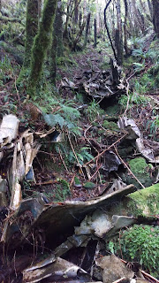
Nearing the top there is a bit of plane wreckage on a stump, this is where we headed approx 150 meters South and in a steep gully we came across bits of the plane and one engine. The wing is quite interesting as the underside is still in good condition.
View under the wing
Top of the wing
The wander along the tops is well marked with a variety of colored tape and the occasional permalot, a lot of the ridge track is freshly cut. However if you need a perfect marked track and sign posts don't bother coming here stick to the great walks, the expression "well marked" is for those who are happy off trail. There are good views along the top.
View from approx 872
There is a tent fly site that has been constructed with a bench and someones stash.
Paul having a much needed rest...
The downhill bit is best done sticking to the highest point of the broad ridge and heading East until you are in the river.
Waitewaewae River
Then it is a short stroll upstream taking the East fork to the hut. The hut book goes back to the 14th March 2008, with 3 parties visiting that year. The most parties in a year where 34 in 2011. We where the 2nd party for 2016.
Island Forks Hut
Island Forks Hut
We lit the outdoor fire and enjoyed a dram before sleeping in the very small hut.

Sunday 10/01/2016
Easier heading up and joining the ridge at the top. Another visit to the plane crash site and we wandered up and down the ridge finding a lot more of the plane, most is in a steep narrow gully.
Gully with much wreckage
Well revisit as want to find the second engine, this is the easy one to find.
Top view
Bottom view
On the way out spotted a dragon fly in the creek on the flats.
Dragonfly
Map of Trip
The pin shows the location of the Island Forks Hut.

NZ Topo BN33 Levin
Trip Times
Saturday 09/01/2016
0855 Left the car parked at
1140 At the plane crash
1214 Up on the ridge where taped track starts
1649 In the river
1659 Island Forks Hut
Sunday 10/01/2016
0822 Left Island Forks Hut
1418 Back at the car