Kohaihai December 2012

23 - 27/12/2012
Family trip of Duangdao, Tariga and I to Kohaihia North of Karamea where we camped for a few days. Scotts beach and beyond.

Kohaihai from the bridge
Beach
Barry's batch
Beach jelly
Bush
Beach to bluffs
A young Glendronach

Orongoronga Valley Day Walk

Sunday 09/12/2012

Drove to the Catchpool stream road end over Wainuiamata and parked at the car park at one thirty'ish and realised I left it a bit late in the day to do my original intention of Mt Matthews. Decided to explore Matthews Stream access to North Saddle.
 Went for 45 minutes up the Matthews stream into the headwaters, an interesting eroded place. On the way back did the Browns Track as I needed some exercise, the up is a track.
However the track down the other side is a bit overgrown. Got to the car before seven as intended as they had a sign stating gate locked at eight.

Map

View Larger Topographic Map

Trip Times
1320 Left the car park
1342 Midway Bridge
1407 Turere Bridge
1500 Heading up Matthews Stream toward North Saddle
1724 Start of Browns Track
1845 Car park

Mangahao Valley

Carl and I had intentions of going up Triangle on Saturday however we cancelled that after we walked to Mangahao Flats hut and realised I had missed Triangle Spur. Still another hut for Carl and a walk.

Friday 30/11/2012
Drove to Poads Road end and headed off across the farm, checked out the locals.
Then headed up the river to South Ohau. We were cold by the time we got to the hut after ten at night. Light the fire and had a feed before sleeping.

Saturday 01/12/2012
We headed to Girdlestone Saddle by continuing up South Ohau and doing the Dowling Falls route. Was almost a lunch time start. Interesting spiders in the creek as we went. These are all photographed by Carl, aint put the here as I think I misplaced the...

Walked much to far and got to the Mangahao Flats hut.
We had a snack and then headed back to Triangle Spur turnoff, arriving there at five thirty.

Due to time and feeling a bit lazy we decided to head to Te Matawai. Got to Te Matawai and could see a pile of boots at the hut so we just continued to South Ohau and it was empty. Except for us and our very toasty feet.
Sunday 02/12/2012
A nice rainy day so we did not come out the river, instead we took the escape route up onto Gables.
No density removal at all, generally a good fun weekend of walk.


South Ohau Longer Way

Planned on a Friday night journey up the Ohau to South Ohau hut, however the rain of Friday put me off that. So I left late Saturday morning thinking the river would have gone down.

Saturday 17/11/2012
I left late in the afternoon expecting the water level to be down. I carried on up to the fly camp and found the water swift and deep. Decided that it was not a good idea to continue, so I headed back and then walked up Gables.
Misty Flats
Woodshed spider
Sunday 18/11/2012
The walk down the river was slow as it was still quite deep and raining.
South Ohau hut
Into the river
Trip Times
Saturday 17/11/2012
1535 Left Poads Road end
1634 Into the river
1645 Fly camp
1720 Back at Gables
1929 Junction at end of Gables
2011 Junction down to South Ohau
2050 South Ohau hut

Sunday 18/11/2012
1344 Left South Ohau hut
1616 North South Ohau junction
1654 Out of the river
1803 Poads Road end

Neill Forks Waiohine Loop Not

A trip with Martin to do the Neill Forks Waiohine loop from Holdsworth car park, that did not work out due to leg muscle failure.

Friday 09/11/2012
Left work at lunch time to get and drove from Wellington to Holdsworth road end. We headed off from the car park just before four p.m. and got to Totara Flats hut before seven p.m.
Flowers at Rocky
Mitre in the distance from near Rocky Lookout
Martin on Swing to Totara Flats Hut
Got to Totara Flats hut before seven p.m. and stopped for a drink and snack before heading off to Neill Forks.
Flowers on way up Cone
Got to Neill Forks in the dark, an evening of nice travel.

Saturday 10/11/2012
A good day and so we headed off up to Maungahuka for lunch on our way to Mid Waiohine. Good views once out of the bush.
Alpine flowers
Tararua Peaks
We did it in a good time and that may be what blew out the muscles, lots of pretty alpine flowers where out. Had a nice long lunch at the hut for some rest and relax as we had decided to abort the trip to Mid Waiohine and return to Neill Forks.
Classic view Maungahuka Hut
Maungahuku Hut
Tararua Peaks
Martin
Swing over river Hector
Back at Neill Forks hut.

Sunday 11/11/2012
Go home day so not too early leaving the hut. A shattering journey for one, with gathering clouds and by the time we left Totara Flats it was raining.
Totara Flats hut
Trip Times
Friday 09/11/2012
1540 Left Holdsworth car park
1041 Rocky lookout
1848 Totara Flats hut
1922 Left Totara Flats hut
2130 Neill Forks hut turn off on Cone Ridge
2227 Neill Forks hut
Saturday 10/11/2012
0924 Left Neill Forks hut
1229 On top of Maungahuka
1234 Maungahuka hut
1436 Left Maungahuka Hut
1445 On top of Mangahuka
1515 Into the bush
1717 Neill Forks hut
Sunday 11/11/2012
1014 Left Neill Forks hut
1130 Cone Ridge
1250 Totara Flats hut
1513 Left Totara Flats hut 
1755 Pig Flat junction
1814 Rocky Lookout
1854 At Holdsworth car park

Map

View Larger Topographic Map


Neill Forks

Solo walk to probably my most favorite East Tararua hut.

Friday 26/10/2012
Walked into Neill Forks hut on Friday night,  was early Saturday by the time I got there. There was a variety of insects out for the evening walk up Cone Ridge and down to Neill Forks.
Green moth is it native?
Millipedes
Flat Red Worm
Wainuia urnula
More millipedes...
Saturday 28/10/2012
Spent the day exploring up and down the Hector river until the cold and deep water was not enjoyable. Back to Neill Forks hut for fire, food, and a dram.
Pool North of Neill Forks
Sunday 28/10/2012
Sunday was a leisurely walk out day with some views along the way.
Green
Cone Ridge sign where old track was
Trip Times
Friday 26/10/2012
1955 Left Holdsworth Road end
2039 Rocky lookout
2109 Pig Flat Junction
2140 Totara Creek
2252 Swing over the Waiohine
2254 Totara Flats hut
2304 Left Totara Flats hut
0102 Neill Forks turnoff
0158 Neill Forks hut
Sunday 28/10/2012
1205 Left Neill Forks hut
1330 On Cone Ridge
1452 Totara Flats hut
1622 Left Totara Flats hut
1831 Pig Flat Kunction
1852 Rocky Lookout
1940 Holdsworth Road end

Map

View Larger Topographic Map

Neill Forks

An exercise trip as its a half day walk to Neill Forks hut with some wee up and downs both ways, and it was raining hard. A great hut to go when your really wet as the fire is awesome and the wood supply plentiful. Good whisky too. Trip whisky being one of the Jura boutique bottles.
Jura Boutique Cask
Scored this one from Centre City Wines and Spirits

Saturday 13/10/2012
Got to Holdsworth and it was bucketing down, so went to the shelter to sort my pack. Quite a few other trampers sitting out the rain.  I headed off and was wet by the time I got to Rocky Lookout.
The Totara Creek track was a minor creek and Totara creek at the bottom was only just passable, had to go upstream and cross it where it was braided. Furthur down the track there was this weird rubbery looking fungi.
Fungi?
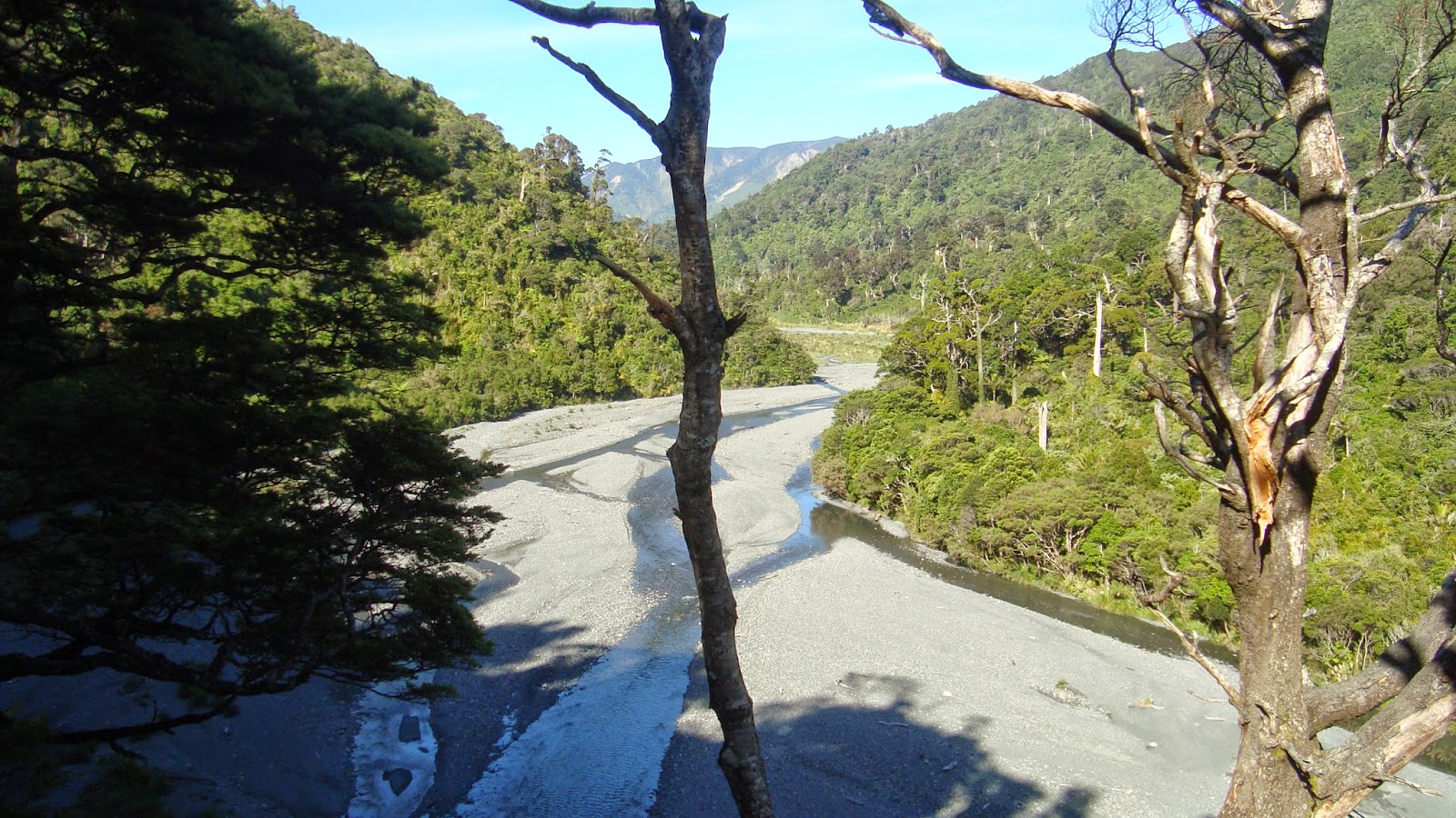
Got to the swing bridge and took a photo as the river was up, as below, and then the next photo is how it was on Sunday on the way back.
Waiohine up
Waiohine down
Stopped at Totara hut for a drink and snack, then off up Cone Ridge into the wind. Cone Peak Wind Speed

Sunday 14/10/2012
I broke my new spoon, one of those things called a spork. Stupid thing. In two its not much useful.
spork rubbish
So now have me something better, this metal thing.
Lifelong spoon
I left Neill Forks after lunch and headed off into the sun, so different weather to Saturday.
View of Tararau Peaks with snow
Last nights snow dusting
Trip Times
13/10/2012
1232 Left Holdsworth car park
1327 Rocky Lookout
1348 Pig Flat junction
1418 Totara Flat creek
1525 Totara Flats hut
1550 Left Totara Flats hut
1745 Neill Forks turnoff on Cone Ridge
1831 Neill Forks hut
14/10/2012
1406 Left Neill Forks hut
1519 Cone Ridge
1651 Totara Flats hut
1708 Left Totara Flats hut
1905 Pig Flat junction
1925 Rocky Lookout
2007 Holdsworth car park


The Place


View Larger Topographic Map

Density
I'm not growing the fish any legs, might have to go North and check out the Ruahines.

Te Matawai

Carl and I doing an Ohau trip, too much rain so we didn't walk up the river, we took Gables track and headed to Te Matawai.

Friday 05/10/2012
A rain walking exercise with Carl, got to the hut after mid night and got a fire going and ate food. A few beers and whiskys later and it was almost four in the morning.

Saturday 06/10/2012
Did not do much this day as it was a sleep in type of day. In the end we decided to head down to South Ohau. It was a fast blast down the hill.
Carl at Te Matawai
Chopper Pad view
Sunday 07/10/2012
We decided to explore the falls up South Ohau before walking out.
Checking out Dowling Falls
View of dusting from top of escape route
Trip Times
05/10/2012
1859 Left Poads Road
2005 Heading up Gables
2248 Richards Knob
2356 Yeates track junction
0031 Te Matawai hut
06/10/2012
1701 Left Te Matawai
1723 Yeates track
1759 South Ohau
07/10/2012
1022 Left South Ohau
Went for a walk up South Ohau to check out Dowling Falls
1335 Back at South Ohau hut
1428 Left South Ohu hut, heading up escape route
1600 Onto Gables
1728 Onto Gorge track
1821 Poads Road car park