Saturday 09/01/2016
We drove to the quarry and parked the car. The walk starts down a farm track that gets rougher as you go. The uphill begins after crossing a small stream. Its a good uphill.
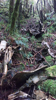
Nearing the top there is a bit of plane wreckage on a stump, this is where we headed approx 150 meters South and in a steep gully we came across bits of the plane and one engine. The wing is quite interesting as the underside is still in good condition.
 |
| View under the wing |
 |
| Top of the wing |
 |
| View from approx 872 |
 |
| Paul having a much needed rest... |
 |
| Waitewaewae River |
 |
| Island Forks Hut |
 |
| Island Forks Hut |
Sunday 10/01/2016
Easier heading up and joining the ridge at the top. Another visit to the plane crash site and we wandered up and down the ridge finding a lot more of the plane, most is in a steep narrow gully.
 |
| Gully with much wreckage |
 |
| Top view |
 |
| Bottom view |
 |
| Dragonfly |
The pin shows the location of the Island Forks Hut.
 |
| NZ Topo BN33 Levin |
Saturday 09/01/2016
0855 Left the car parked at
1140 At the plane crash
1214 Up on the ridge where taped track starts
1649 In the river
1659 Island Forks Hut
Sunday 10/01/2016
0822 Left Island Forks Hut
1418 Back at the car

1 comment:
I visited the main crash site in July 1999. I remember that one of the motors was there, also part of the undercarriage with its main leg still bright and shiny, and the second wing was stuck high up in a tree. The first wing ripped off can be found higher up, close to the track to Mick.
Post a Comment